Air raids on Prague in 1944-1945
At the end of World War II, Prague was the target of aerial bombardment on three occasions. Newly-released aerial photographs taken by Allied reconnaissance aircraft will show you where the destructive bombs landed, and will allow for an extraordinarily detailed examination of Prague’s appearance at the end of the German occupation.
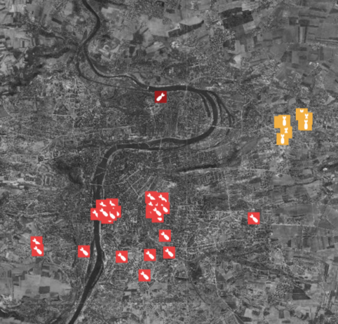
At the very end of World War II, Prague suffered its share of extensive damage and loss of life. It was targeted by three air raids: first on 15 November 1944, then on 14 February 1945 and lastly on 25 March 1945. The air raids on Prague resulted in the loss of more than 1,200 lives, with the worst damage occurring in the districts of New Town, Holešovice, Smíchov, Vršovice, Vinohrady, Žižkov, Libeň, Kbely, Letňany and Čakovice.
In 2015, the Prague Institute of Planning and Design was offered the chance to make use of unique aerial photographs taken by Allied reconnaissance aircraft shortly before the end of World War II in April and May 1945. The photographs are the property of the German company of Luftbilddatenbank Dr. Carls GmbH, whose sole partner in the Czech Republic is PRIMIS spol. s r.o. The photographs, whose image quality and detail are outstanding, were taken to assess the success of bombing missions by the RAF and US AAF. The photographs are currently used mainly in Germany as an indispensible source of information for detecting risks of unexploded munitions when building projects are being prepared.
In the case of Prague, an extraordinarily fortunate coincidence made it possible to put together enough image material to produce a comprehensive orthophoto of the entire existing administrative ward. Photographs from 10 reconnaissance missions undertaken after the air raids at the end of April and in the first days of May 1945 were used. The images’ scale ranges from 1:7,000 to 1:50,000.
The resulting orthophoto is an utterly unique work, because it allows for a detailed examination of Prague’s appearance at the end of the German occupation. “Besides buildings, streets and squares, the aerial photographs make it possible to clearly identify both the results of the bombing and anti-aircraft and other defence equipment, fire water reservoirs and other features. It’s an utterly unique creation,” adds Ondřej Boháč, Director of the Prague Institute of Planning and Development.
To bring the historic reality closer to present-day users, the app for viewing the photographs also offers commentary on the buildings shown, combined with period photographs from the Institute’s archive. The accompanying information will be gradually expanded.
Click here to access the app.
You might also be interested in
Prague residents live in economically mixed areas, according to a new analysis by IPR Prague.

DEVADE: Prague's Architecture Amidst Austerity and Disco. A new book and exhibition at CAMP map Prague of the 1990s.