Explore Prague with a New 3D Model Application
Now you can explore Prague in 3D from anywhere, thanks to a new application released by IPR Prague. Unlike Googlemaps and other programs, the application provides a wide range of detailed information about every building: for instance, it can tell you how many floors a building has and who owns it.
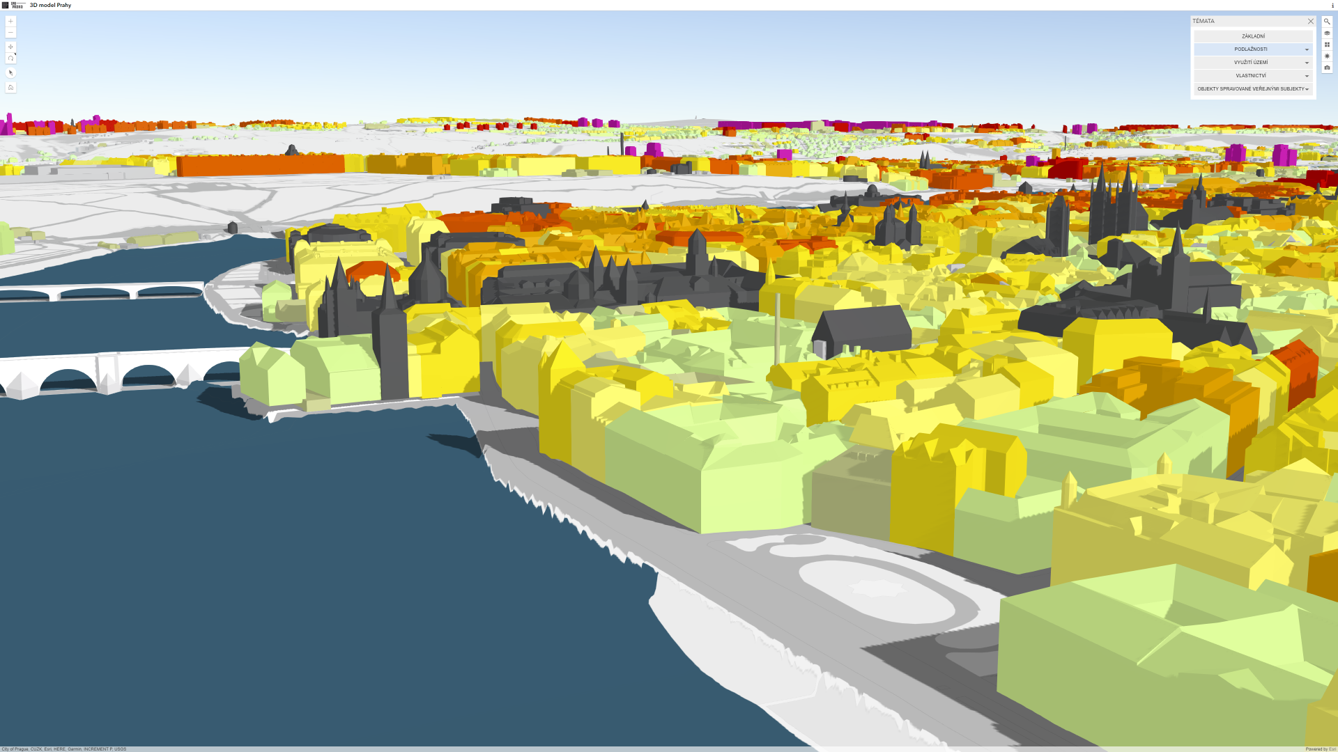
The 3D model includes data on more than 200,000 buildings throughout the city. “Our 3D model is truly exceptional. Its main advantage is that it is not just a three-dimensional depiction of the city as though you were in an IMAX cinema. Rather, our model includes actual data on the buildings themselves. This means that you can find information about every building in Prague,” explains the Institute’s director, Ondřej Boháč.
The application allows to you search by address; once an address is entered, the specified building is automatically highlighted on the map. The user can then see how many floors each building has, how it is used, who owns the plot, and, eventually, which public authority administers the building. That’s not all, though. “Thanks to the application, people can enjoy the view from the best-known vantage points in Prague. The application can bring the user to 24 spots around the city from where they can admire the metropolis.
My favorite views of the city are from the Novotný footbridge and from Ke Hradu street leading up to Prague Castle from the south,” adds Boháč. The application even allows you to set the date and time of day when you want to visit a particular place. That makes it possible to see how the illumination of various places changes over the course of the year, or it can show you how the shadows in your street change throughout the day. The application also lets you select which underlying map you’d like to use; you can choose between a technical map and an orthophoto.
The extent of the buildings and the technologies used make this a unique application for displaying the 3D city model of the city. The application is based on ESRI technology; in June 2017, IPR won a “Special Achievement in GIS 2017” award from ESRI, the world’s largest supplier of spatial data software. Making the city’s 3D model available to both experts and the general public is one of the outcomes of IPR’s long-term monitoring of trends in the management and presentation of 3D models of cities.
You can find the 3D model application here: https://app.iprpraha.cz/apl/app/model3d/
You might also be interested in
Prague residents live in economically mixed areas, according to a new analysis by IPR Prague.

DEVADE: Prague's Architecture Amidst Austerity and Disco. A new book and exhibition at CAMP map Prague of the 1990s.